Did you know your geological model does not need to have a basic set of rectangular extents? Seequent Civil and Environmental Customer Solutions Manager – Michaela Crum, explains how…
One interesting question our Customer Solutions Specialist team gets asked is about refining a geological model’s extents to correspond to a particular area of interest. In Leapfrog Works, geological models can have extents defined by other data in the project such as a property boundary polygon. They can also be restricted to a known distance from boreholes by applying a distance function, such as a lateral extent. Model extents do not need to be vertical surfaces and it’s even possible to define a base that serves as the model’s bottom boundary. This is a particularly helpful feature to enable you to refine your geological model to fit your needs.
In Leapfrog Works, a geological model can have a boundary defined by a new lateral extent and/or a new base. A list of data that can be used to define the boundaries is illustrated below:
New Lateral Extent
- From Polyline
- From GIS Vector Data
- From Points
- From Structural Data
- From Surface
- From Distance to Points
- From Distance Function
New Base
- From Polyline
- From GIS Vector Data
- From Points
- From Structural Data
- From Base Lithology
- From Other Contacts
- From Surface
To create an extent, expand the model in the project tree. Right-click on the Boundary object and select from the New Lateral Extent or New Base options and the data type to define the new boundary. Follow the prompts to create the extent, which will then appear in the project tree under the model’s Boundary object.
Some ideas where this option can be helpful is to create a lateral extent for your model to be refined by a property boundary for your project.
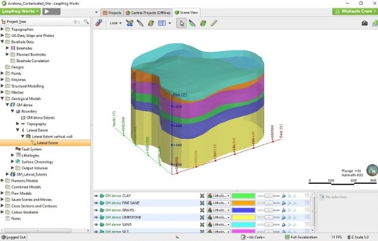
The image below is a geological model that has been refined by a polygon for the lateral extent.
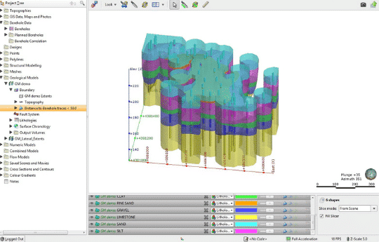
Another application is to create a lateral extent From Distance Function to refine the geological model to a certain distance away from borehole data.
Using the same model from above, the lateral extents are now shown where the model exists within 50m of borehole data.
It’s an easy option to apply and if the data changes, the model will automatically be updated. For example, if your lateral extent is defined by a distance to borehole function, then when you add new boreholes to your database, the model boundary is automatically updated. This makes updating your model with new data a breeze.
These examples of how to use the tool are just to get you started. Have you used the model boundary tool before? How have you refined your model? We always like to hear from you, so please feel free to leave comments and share your ideas.